
Maps of Upper Saddle River
We thought it might be useful to people researching their roots in Upper Saddle River to provide examples of some of the known maps that were done by different cartographers over the years. Below is one of the earliest (1861) and most detailed maps that includes Upper Saddle River. The current town straddles the line between the red and green sections indicated as HoHoKus and Harrington Townships on the map. This map is available in its entirety through Princeton University. We have also included a series of other maps from various different times, several of which also indicate the location of homes and other structures, though in most cases streets are not named. If one compared them to modern street maps you would likely see East Saddle River Road, West Saddle River Road, Weiss Road, Lake Street, Pleasant Avenue, Union Avenue and Carlough Road, which should be evident on each of these maps. Enjoy!
1861 Wall Map
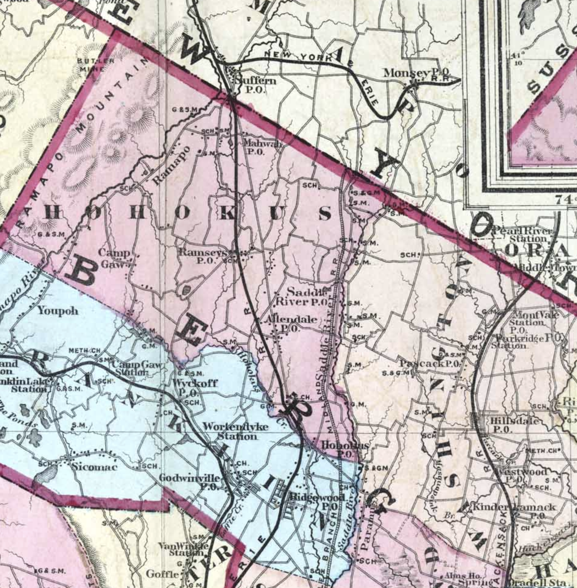
![Griffith Morgan Hopkins, Jr. "Map of the Counties of Bergen and Passaic, New Jersey: From Actual Surveys" (Philadelphia: G. H. Corey, Publisher, 1861) [Library of Congress]. This was a large-scale wall map, with ornamental border and added color, 13…](https://images.squarespace-cdn.com/content/v1/5f31ba32999717677bd5dfec/1597589254818-V1NK7FDTU0U5UF88D5XS/1861.jpg)
Griffith Morgan Hopkins, Jr. "Map of the Counties of Bergen and Passaic, New Jersey: From Actual Surveys" (Philadelphia: G. H. Corey, Publisher, 1861) [Library of Congress]. This was a large-scale wall map, with ornamental border and added color, 139 × 113 cm. Scale: 1 mile to 1.5 inches. At the time this map was produced Bergen County was made up of nine townships, colored blue, yellow, green, or pink: Franklin, Hackensack, Harrington, Hohokus, Lodi, New Barbadoes, Saddle River, Union, and Washington
1861 Map Detail

This is a detail of the above map. The Hopper-Goetschius house is marked on the map nearly in the exact center, in the green section. The Terhune-Hopper house is just to the left in the red section after the sharp jog in the road, now called Lake Street. Hairpin Turn did not yet exist.
1872 MAP
This Topographical Map of Bergen and Passaic Counties indicates the location of schools, saw and grist mills and also the railroad that was never constructed, labeled Saddle River Railroad. How different things would have been! The full map is in the collection of Rutgers University.
1876 Map
![This is a detail of the Atlas of Bergen County, New Jersey made from surveys of each town and village. By: A. H. Walker and published in Reading, Pa. by C. C. Pease, [1876]; Winterthur Call Number: RBR F142 B49 F, Order Number: 05L157. This was cons…](https://images.squarespace-cdn.com/content/v1/5f31ba32999717677bd5dfec/1597625323975-PUSJ4105UVEL7ERGEWHR/1876_West.jpg)
This is a detail of the Atlas of Bergen County, New Jersey made from surveys of each town and village. By: A. H. Walker and published in Reading, Pa. by C. C. Pease, [1876]; Winterthur Call Number: RBR F142 B49 F, Order Number: 05L157. This was considered the first atlas of Bergen County. The volume contains maps of all continents, the U.S., and New Jersey as well as information about the county, towns and villages, with listing of county officers and a table of distances between county villages. The detailed work was done by George Allen Rudd (1853–1888). Its accuracy is remarkable.

This is a detail of the previous map showing households west of the river including those on West Saddle River Road, Union and Pleasant Avenues, Lake Street, Old Stone Church Road and Sparrowbush Road. The current town was divided onto two plates in the book. See below for the eastern portion.
1876 map detail of page including eastern portion of upper saddle river

The orientation of this map is different, but it shows the portion of Upper Saddle River (bottom left in yellow) that extends to the east of the Saddle River. S. J. Goetschius indicates the property then owned by Steve prior to his marriage to Lizzie.

The eastern portion of town enlarged again. At the far left is the Van Buskirk-Penner house. To the right is Weiss Road, then the corner of Old Stone Church Road. Further to the right is the intersection of East Saddle River Road and Lake Street with “S.J. Goetschius” indicating the location of the Hopper-Goetschius house.
1902 MAP
This 1902 map included portions of Passaic County. It was published by E. Robinson & Co. Montvale Road is now Lake Street and Upper Saddle River Road is now Weiss Road.
1912 map

Bergen County 1912 Vol 2, New Jersey, Published by G. W. Bromley & Co. in 1912. This is a section of Plate 031, which depicted Hohokus, Franklin, and Orville Townships. The orientation has been rotated 90 degrees from the original to align better with our current understanding. The Goetschius property is shown with 3 markings - perhaps including the out kitchen and barn. Mayor Herman T. Hopper owned the two houses on the corner of Lake Street and West Saddle River Road at the time.
1935 Assessment Atlas, Upper Saddle River

This detailed property map was produced by F. D. Livermore, Borough Engineer for the town of Upper Saddle River. It dates to June, 1935. The area shown includes properties north of Lake Street and east of East Saddle River Road. The orientation is 90 degrees clockwise to our current understanding.
This map was
1936 assessment atlas showing road names


This detailed map was created in 1962 by the late Bergen County historian and Upper Saddle River resident, Claire Tholl. Claire was part of a committee who conducted the Historic House Survey. She personally visited, photographed and researched homes, deeds and maps to compile this priceless visual of the town and most of its current and also demolished homes. Visit our Shop page to order your own copy printed on parchment.